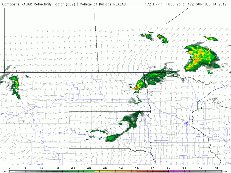
Above the latest HRRR model depiction of what storms might look like later this evening/overnight for parts of Saskatchewan and Manitoba. We are still expecting storms to develop late-afternoon in Saskatchewan and move towards Manitoba overnight. Some isolated storms may form near the SK/MB border and become severe. The most likely scenario will be storms initiating in the evening hours near the SK/MB border, these could be quite severe and have a conditional threat for tornadoes.
Latest satellite imagery (shown above) depicts a possible outflow boundary near the SK/MB border, or near Swan River, MB. This may act to enhance low-level shear and initiate thunderstorms later this evening. We still think there is a chance of some strong storms in the Westman region with a conditional threat for tornadoes, especially in the evening hours.
Fronts are depicted above, as you can see, a fairly complex interaction between fronts, local terrain enhancement and possible outflow boundaries may lead to robust thunderstorms later today and overnight.
Current Watches
Watches
1:35 PM CDT Sunday 14 July 2019 Severe thunderstorm watch in effect for areas in yellow:
Conditions are favourable for the development of dangerous thunderstorms that may be capable of producing strong wind gusts, damaging hail and heavy rain. A hot and humid airmass combined with a weak low pressure trough will cause thunderstorms to develop this afternoon. A few of these thunderstorms are likely to become severe from late this afternoon through most of tonight. This watch area may expand southward and eastward later today as conditions warrant. Very large hail can damage property, break windows, dent vehicles and cause serious injury. Lightning kills and injures Canadians every year. Remember, when thunder roars, go indoors! Severe thunderstorm watches are issued when atmospheric conditions are favourable for the development of thunderstorms that could produce one or more of the following: large hail, damaging winds, torrential rainfall.
Latest PASPC Outlook
Saskatchewan
Area(s): Central and Southern
Timing: This afternoon and evening
Threats: 2-4 cm hail, wind gusts up to 110 km/h and risk of tornado.
Scattered strong to severe thunderstorms likely across much of southern and central regions developing this afternoon and tracking eastward into the evening. Large hail up to 4 or 5 cm are possible along with strong wind gusts of 110 km/h. There is a risk of tornadoes over southeastern portions of the province.
Manitoba
Area(s): Southern and central regions.
Timing: Early this morning then again this evening into the overnight hours.
Threats: Hail up to 4-5 cm and strong wind gusts of 110 km/g possible. Tornadoes are possible this evening over southern regions.
Strong thunderstorms early this morning then strong to severe storms expected to develop over southern SK and track into southern Manitoba this evening and continue into the overnight hours.


Comments